Map of brick kilns, satellite cities, power plants (created by Sarath Guttikunda and Giuseppe Calori): http://www.urbanemissions.info/delhi-india/
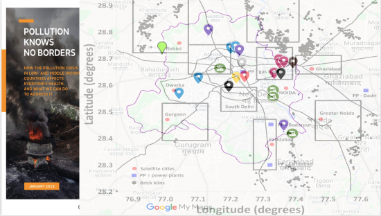
Map of Delhi's toxic hotspots (I created it using Google Maps with input from this) report.
The image on the right is from PureEarth
Prerna Srigyan, Sarath Guttikunda, PureEarth and Toxics Link, "Bordering toxicity ", contributed by Prerna Srigyan, Center for Ethnography, Platform for Experimental Collaborative Ethnography, last modified 24 February 2020, accessed 23 February 2025. http://centerforethnography.org/content/bordering-toxicity

Critical Commentary
Air's ability to move and disperse toxic chemicals while disregarding political boundaries makes it both a particularly intractable object of governance and unifies advocates to demand for cleaner air. Regulators and advocates alike remark on the complexity and dynamism of air. Imaginations of flow, however, have political implications. Air's flows are never imagined in a vaccuum. Air pollution always moves from a polluting source (stationary or mobile) to a cleaner source. They become lenses through which developmentality operates, becoming inseparable from geopolitics. They offer new rankings for places.
Delhi's air has many spatial valences: neighborhood, urban, regional, national, even transnational. And even as toxics complicate scale, they become known as equalizers. As air crosses borders, it affects everyone, and everyone must unite, goes the advocate's logic, even as they know that air pollution does not affect everyone equally. The right for clean air becomes an individual right, a human right, even though advocates know it is a matter of social justice. Why is it so hard for advocates in Delhi to visualize air as a shared yet fragmented experience? What hinders solidarity while acknowledging differences of exposure? What visualisation strategies can be helpful?
I think that one way to disrupt the toxic air-as-equalizer narrative is to simply show that it does regard borders. Not fully, but the way people have to live in, and the way polluting entities become concentrated, makes breathing at the borders precarious. Nor do borders mesh with political borders. They can be frontiers of capital and infrastructure, the borders between our bodies, the borders between our home and the world beyond.
I created this map using two sources: a 2014 report on Delhi's toxic hotspots by the non-government organisation Toxics Link and a 2013 scientific peer-reviewed article by Sarath Guttikunda and Giuseppe Calori. I made the underlying map of Delhi using Google Maps and marked the toxic hotspots indicated by the 2014 report. Then I overlaid the GIS image created by Guttikunda and Calori on Delhi's map, zoomed out to match with the GIS image approximately. There is slight incorrespondence between the two images, mainly because of a lack of technical skill. Despite that, I think the image (both found and created) shows that there are clearly toxic hotspots and clusters near Delhi's actual political borders (marked in red).
A demand for cleaner air has to be attentive to such spatial injustices, particularly as polluting sources have been placed at the peripheries in earlier moments to "decongest" Delhi by moving its polluting factories and workers elsewhere.